
A Guide to Walking the Cotswold Way
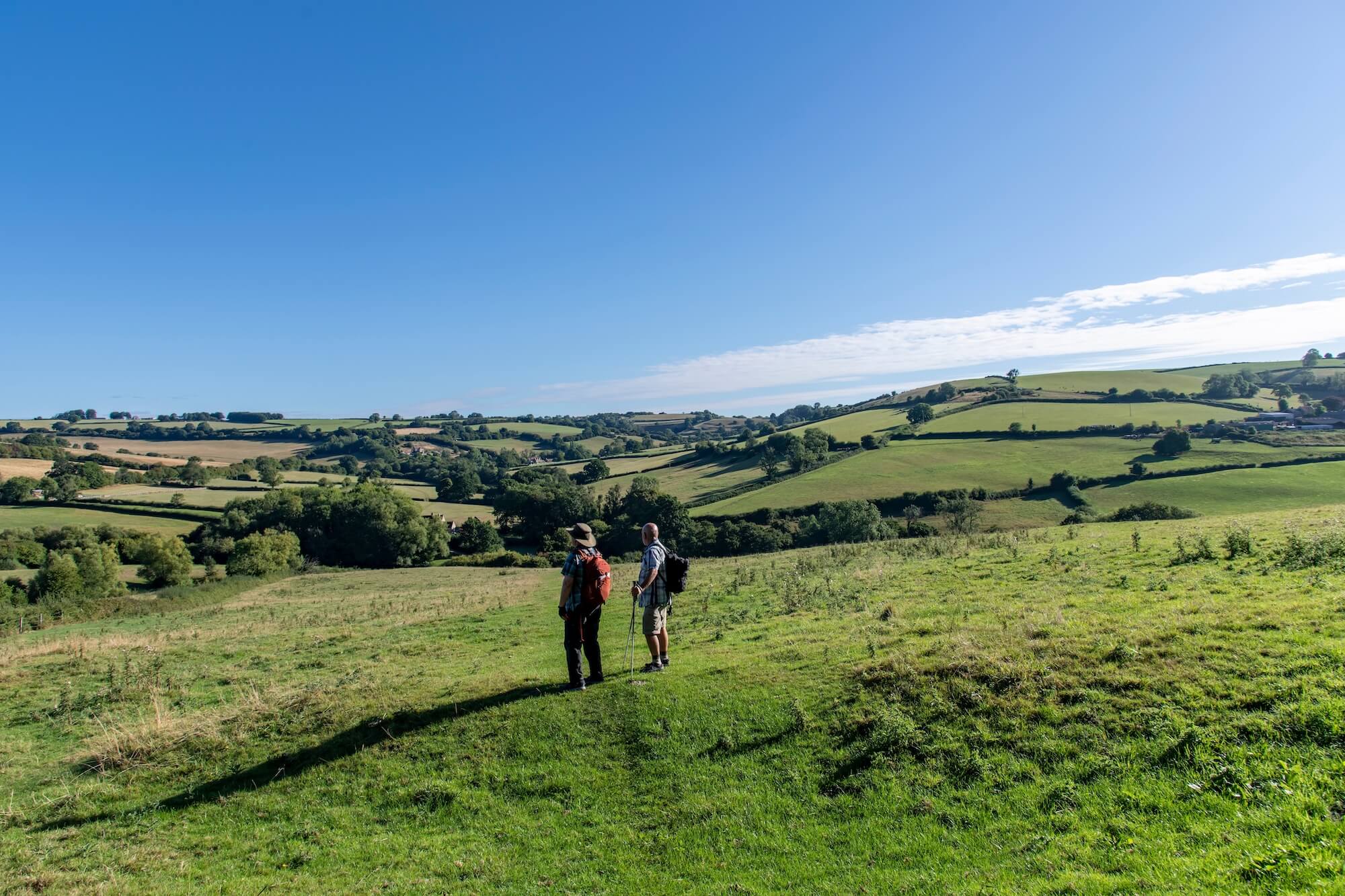
The Cotswold Way offers some wonderful walking country on the approach to Bath, with rolling hills, quiet valleys, historic villages and far-reaching views across the surrounding countryside. Whether you’re completing the final miles of this famous National Trail or simply looking for a rewarding countryside walk during a stay in the area, the section near the city of Bath in North East Somerset has plenty to enjoy.
As the route approaches the city, the landscape gradually changes from open farmland and wooded valleys to the high ground of Lansdown, where views towards Bath provide a memorable introduction to the historic city. The trail then descends through Weston and the western outskirts of Bath before reaching its official finishing point outside Bath Abbey.
Staying in this area makes it possible to combine a day on the Cotswold trail with time exploring Bath and the surrounding countryside. Toghill House Farm on the outskirts of Bath offers a practical accommodation option for walkers, situated approximately 1.5 miles from the main Cotswold Way route. That additional distance needs to be factored into your plans, and it’s important to use the recommended pedestrian route rather than walking along unsuitable roads.
In this guide, we’ll look at what to expect from the Cotswold Way near Bath, the best sections to explore, and how to plan your walk, including food, transport and overnight accommodation.
What Is the Cotswold Way?
The Cotswold Way is a 102-mile (164km) National Trail running between Chipping Campden in Gloucestershire and Bath. It follows much of the western edge of the Cotswolds, passing through attractive villages, open countryside, ancient woodland and landscapes rich in history.
The route is known for its varied scenery. In the northern Cotswolds, walkers encounter honey-coloured stone villages, historic market towns and sweeping views from the escarpment. Further south, the landscape becomes more gently rolling in places, with farmland, wooded valleys, historic estates and elevated viewpoints.
Although the Cotswold Way is often completed over several days, you don’t have to walk the entire route to appreciate it. Individual sections offer excellent opportunities for day walks, weekend breaks and shorter visits to the countryside. You can also combine walking with visits to historic attractions, traditional villages and the city of Bath itself.
For those walking the entire trail from north to south, Bath is the destination at the end of the journey. Reaching Bath Abbey after 102 miles of walking is a fitting conclusion, bringing the countryside route to an end in one of England’s most distinctive historic cities.
The final stage, from Cold Ashton to Bath, is approximately 10 miles long and typically takes around four-and-a-half to six hours to cover, depending on pace, conditions and stops. It combines open countryside, substantial changes in elevation and increasingly urban surroundings as you approach the city.
Where Does the Cotswold Way Go Near Bath?
The approach to Bath is one of the most varied sections of the trail. After leaving Cold Ashton, the route crosses farmland and descends towards the valley around Lower Hamswell before climbing towards Lansdown. From there, it follows the high ground towards Bath Racecourse and continues towards the city.
Key places and landmarks along the way include:
- Cold Ashton: A small Cotswold village surrounded by rolling farmland, marking the beginning of the final stage into Bath.
- Lansdown: Elevated countryside with open views, historic associations and a landscape that has witnessed significant events, including the Battle of Lansdown in 1643.
- Prospect Stile: A notable viewpoint where Bath comes into view, giving walkers a first clear sense of their destination.
- Weston: A village on the western edge of Bath, where the trail begins to feel more urban.
- Royal Victoria Park: A substantial green space near the city centre, providing a pleasant contrast to the streets beyond.
- Bath city centre: The final approach takes walkers through the historic city, with its Georgian architecture and distinctive streetscapes.
- Bath Abbey: The official southern terminus of the Cotswold Way, marked by a stone disc in the pavement outside the Abbey’s west doors.
Best Cotswold Way Walks Near Bath
You don’t need to be undertaking the full National Trail to enjoy walking in this area. The following options offer different ways to experience the Cotswold Way and its surrounding countryside, from the final approach into Bath to shorter outings focused on the views.
Cold Ashton to Bath
For walkers who want to experience the Cotswold Way as it approaches its official finishing point, the walk from Cold Ashton to Bath is an excellent choice.
The route is approximately 10 miles long, with a typical walking time of four-and-a-half to six hours. Allow extra time if you plan to stop for photographs, refreshments or sightseeing along the way.
The walk begins in open countryside, crossing fields and descending into the secluded valley around Lower Hamswell. The landscape then rises towards Lansdown, where the route reaches more elevated ground and offers increasingly expansive views. Historic features, farmland and open hillside make this a varied day’s walking rather than simply a route from A to B.
As you approach Bath Racecourse, the trail follows the plateau before reaching Prospect Stile, where the city comes into view. The route then descends through Weston and continues through the western side of Bath, eventually reaching Bath Abbey.
The walk is moderately demanding to challenging for some walkers, largely because of its length, climbs and descents. Good footwear and a reasonable level of fitness are advisable.
Transport considerations: If you’re walking from Cold Ashton into Bath, plan your return journey before setting out. Depending on where you’re staying, you may need a taxi, local bus or other transport to return to your starting point. If you’re using Toghill House Farm as your overnight base, remember to account for the additional walking distance between the property and the main trail.
Lansdown to Bath
Lansdown provides another attractive starting point for exploring the final section of the Cotswold Way. This option allows you to experience some of the route’s most rewarding views without necessarily walking the entire stage from Cold Ashton.
The distance and walking time depend on your precise starting point and the route you choose to join the trail, so check a current map before setting out. An example would be a 6-mile moderately difficult walk from the Lansdown Park & Ride (BA1 9BJ) to Bath Abbey.
Much of the appeal lies in the elevated landscape. Open fields, broad skies and long views across the countryside characterise this part of the walk. Prospect Stile is a particular highlight, offering a memorable view towards Bath before the route begins its descent towards the city.
From here, the scenery gradually changes. Rural paths give way to the outskirts of Bath, with Weston and the city’s green spaces providing stepping stones towards the centre. Finishing at Bath Abbey gives the walk a clear destination and the opportunity to explore Bath’s historic streets afterwards.
Although this is generally a more manageable option than walking the entire Cold Ashton stage, don’t underestimate the hills and the descent into Bath. The route is not uniformly flat, and muddy or slippery paths can make progress slower in wet weather.
For a point-to-point walk, check transport options at both ends. If you’re travelling from accommodation outside the city, make sure your return arrangements are straightforward before you leave.
Bath to Kelston Roundhill and Back
If you would prefer a circular walk rather than a point-to-point journey, the countryside around Kelston Roundhill offers a rewarding alternative.
Kelston Roundhill is a distinctive landmark on the hills west of Bath. Its elevated position provides impressive views towards Bath and Bristol on a clear day, making it a worthwhile destination for walkers who enjoy open countryside and panoramic viewpoints.
One established circular option is approximately six miles long and takes around three-and-a-half hours. The route includes a section of the Cotswold Way and a detour to the summit of Kelston Roundhill, returning via Prospect Stile and the Lansdown area. The exact route and starting point should be checked before setting out.
Expect some steep slopes, particularly on the approach to the higher ground. This is a moderate walk rather than an entirely gentle stroll, but it offers an excellent opportunity to enjoy the landscape without committing to a full day’s walking.
There are different ways to organise a return journey, depending on where you begin. A circular route avoids the need to retrace your steps throughout, while public transport or a pre-arranged lift may be useful if you choose a linear walk.
A Short Cotswold Way Walk From Bath
If you have only a few hours available, you can still enjoy a section of the Cotswold Way near Bath without tackling a full stage.
One option is to begin around Lansdown and walk towards Prospect Stile, taking time to appreciate the views before turning back. Your distance will depend on your chosen starting point and turnaround location.
Alternatively, walkers already exploring Bath could head towards the western side of the city to join the trail, following it out towards the countryside before returning by the same route. Remember that the climb away from the city can be more strenuous than it first appears.
A shorter walk gives you the flexibility to take your time, stop for photographs and enjoy the views without worrying about reaching a distant destination before dark. It’s particularly suitable if you’re visiting Bath for a weekend and want to combine a little countryside walking with sightseeing in the city.
Check the route carefully before leaving, as a short out-and-back walk can become longer than expected if the terrain is steep or conditions are muddy.
Highlights of the Cotswold Way Around Bath
The final part of the Cotswold Way combines countryside, history and views with the anticipation of reaching Bath. These are some of the highlights to look out for:
Bath Abbey
The official finish of the National Trail is marked by a circular stone disc in the pavement outside Bath Abbey’s west doors. For anyone completing the full 102-mile route, reaching this point is a significant moment. The Abbey itself is a striking historic building in the heart of Bath, surrounded by streets filled with shops, cafés and places to eat.
Cold Ashton
This attractive rural village provides a peaceful starting point for the final stage into Bath. Its setting among rolling farmland offers a reminder of the countryside character that defines much of the Cotswold Way.
Lansdown
The elevated landscape around Lansdown combines open countryside with a rich history. The area was the site of the Battle of Lansdown during the English Civil War, and walkers can enjoy the sense of space that comes with being on high ground above the surrounding valleys.
Prospect Stile
For many walkers, this is one of the most memorable points on the approach to Bath. The view towards the city provides a welcome reward after the climb onto Lansdown and signals that the destination is getting closer.
Kelston Roundhill
The prominent hill and its distinctive group of trees make Kelston Roundhill easy to recognise. On a clear day, the summit provides far-reaching views across the surrounding countryside towards Bath and Bristol.
The historic Lansdown landscape
Beyond its views, this area offers a sense of the historical depth of the Cotswolds. Ancient earthworks, historic landmarks and the wider landscape all contribute to the character of the walk.
Views over Bath and the surrounding countryside
The transition from open countryside to city is one of the pleasures of this final stage. The views change as the route progresses, from broad rural panoramas to glimpses of Bath’s historic buildings and green spaces.
Where Does the Cotswold Way Finish in Bath?
The Cotswold Way officially finishes at Bath Abbey, in the centre of Bath. A circular stone marker set into the pavement outside the west doors marks the southern terminus of the 102-mile National Trail.
For walkers who have completed the entire route, this is the point at which the journey from Chipping Campden comes to an end. Even if you’re walking only the final stage, the Abbey provides a satisfying destination after a day of countryside paths, hills and changing scenery.
The last part of the route takes you through Weston and the western outskirts of Bath before leading towards the city’s green spaces and historic centre. The transition can feel quite dramatic after hours spent walking through fields and open countryside.
Once you reach the Abbey, you’ll find plenty of opportunities to stop for refreshments, enjoy a meal or spend time exploring Bath. The Roman Baths, historic streets and Georgian architecture are all within reach of the city centre.
Bath Spa railway station is approximately a 10–15-minute walk from Bath Abbey, making it convenient for walkers planning to travel onwards by train. Check current public transport information if you need to return to your starting point or connect with accommodation outside the city.
How Difficult Is the Cotswold Way Near Bath?
The difficulty of walking the Cotswold Way near Bath depends on the distance you choose and your experience of walking on varied terrain.
The final stage from Cold Ashton to Bath is approximately 10 miles long. While this is achievable for many reasonably fit walkers, it includes several climbs, a substantial overall descent and a mixture of rural and urban walking.
Hills and elevation
The route descends into the valley around Lower Hamswell before climbing towards Lansdown. Although the final approach into Bath is predominantly downhill overall, the earlier ascent can be demanding, particularly if you’re already carrying a full pack.
Terrain and footpaths
Expect a mixture of field paths, tracks, woodland sections and paved streets. Some stretches are relatively straightforward, while others involve uneven ground, gates and changes in gradient.
Mud and seasonal conditions
After rain, field paths can become muddy and slippery. In winter, shorter daylight hours can also make longer stages more challenging. Waterproof footwear and clothing are worth carrying throughout the year.
Fitness requirements
You don’t need to be an experienced long-distance walker to enjoy the area, but you should choose a distance that suits your fitness and allow enough time to complete it comfortably. If you’re unsure, a shorter walk around Lansdown or Kelston Roundhill may be a better starting point.
Short walks versus longer stages
A few hours on the trail gives you the chance to enjoy the scenery without the demands of a full day’s walking. By contrast, walking from Cold Ashton to Bath requires more planning, including food, water, transport and sufficient time to reach your destination.
Walking Between the Cotswold Way and Toghill House Farm
Toghill House Farm is a guest house situated approximately 1.5 miles from the main Cotswold Way route, making it a useful base for walkers exploring the countryside near Bath or completing the final stage of the National Trail.
However, be aware of the fact that this is not a case of simply following the nearest road from the trail to the accommodation. Some of the surrounding roads are busy and do not provide suitable pedestrian space. Walkers should therefore use the recommended route via footpaths through Cold Ashton and the surrounding countryside.
Allow for the additional distance when planning your day. If you’re completing the final stage into Bath, for example, the walk between the trail and the accommodation will add to your overall mileage. It’s worth considering this when deciding on your starting time, how much food and water to carry and whether you want to make any additional stops.
Important Safety Information for Walkers
Do not walk along Gorse Lane.
Gorse Lane is extremely busy and does not have a suitable verge for pedestrians. It is not a safe route to use on foot.
Instead, follow the recommended pedestrian route via footpaths through Cold Ashton and the surrounding countryside. The directions below explain how to reach Toghill House Farm from the Cotswold Way.
The route includes crossings of the A46 and A420, so take particular care. Cross only where it is safe to do so, remain alert to traffic and do not assume that a verge or roadside path is available throughout. If conditions make a crossing unsafe, wait until it is safe to proceed.
Walking Directions From the Cotswold Way
The following directions describe the recommended pedestrian route towards Toghill House Farm. Use them alongside a suitable map and the accompanying photographs to help identify the footpaths.
1. Walk through Cold Ashton
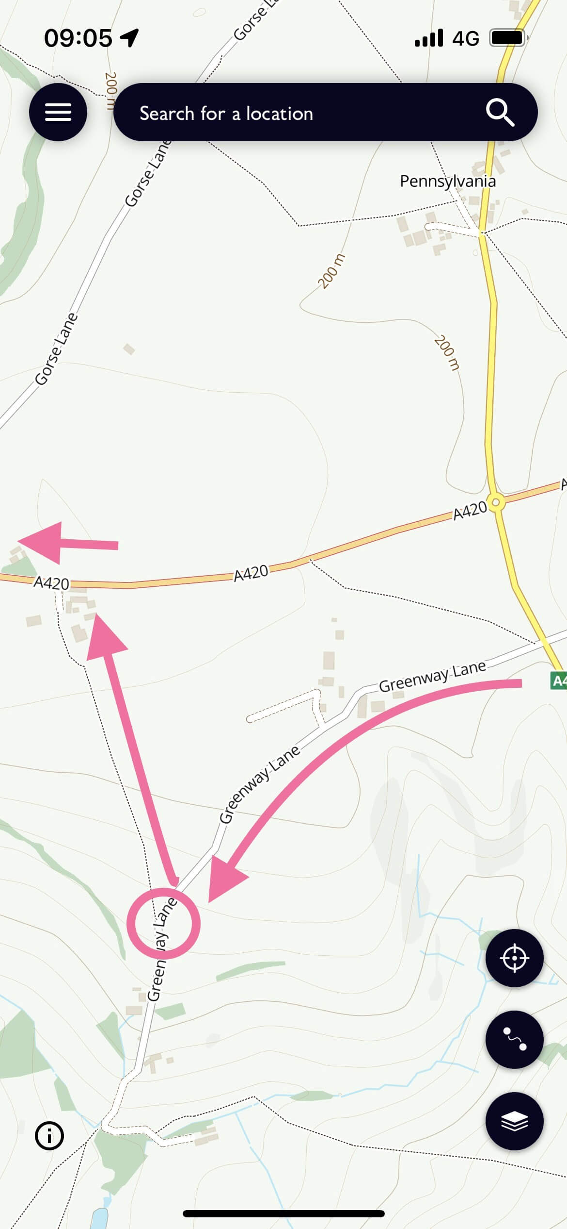
Follow the trail through Cold Ashton, cross the A46 and continue onto Greenway Lane.
Continue along Greenway Lane for approximately half a mile, keeping an eye out for the footpath entrance described below.
2. Take the footpath towards Toghill Barn Farm
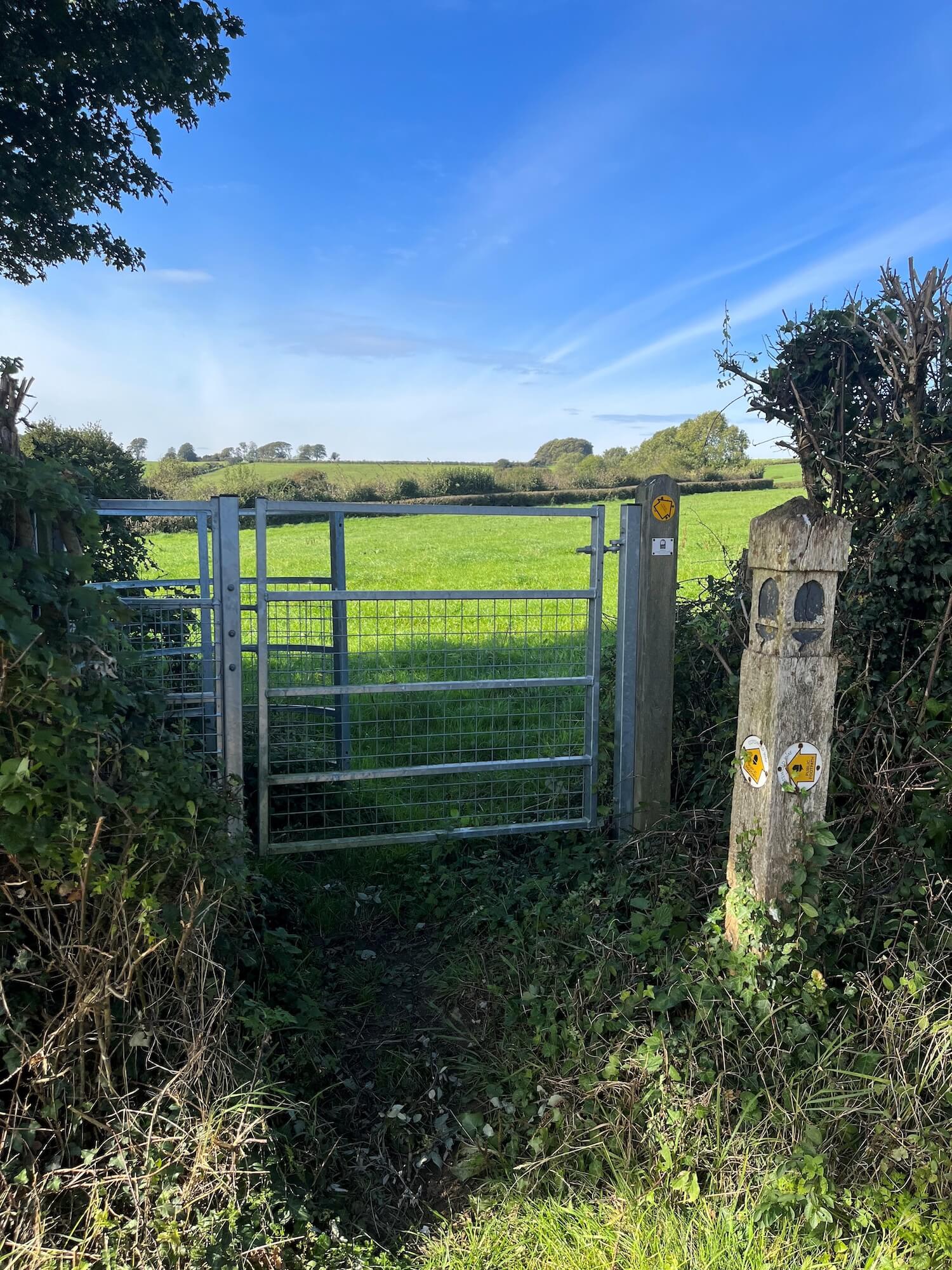
Look for a metal footpath gate on the right-hand side and take the footpath through it. If you reach Special Plants, you have gone too far.
Follow the footpath diagonally across the field towards the far hedge. Continue alongside the hedge in the direction of Toghill Barn Farm.
3. Cross the A420
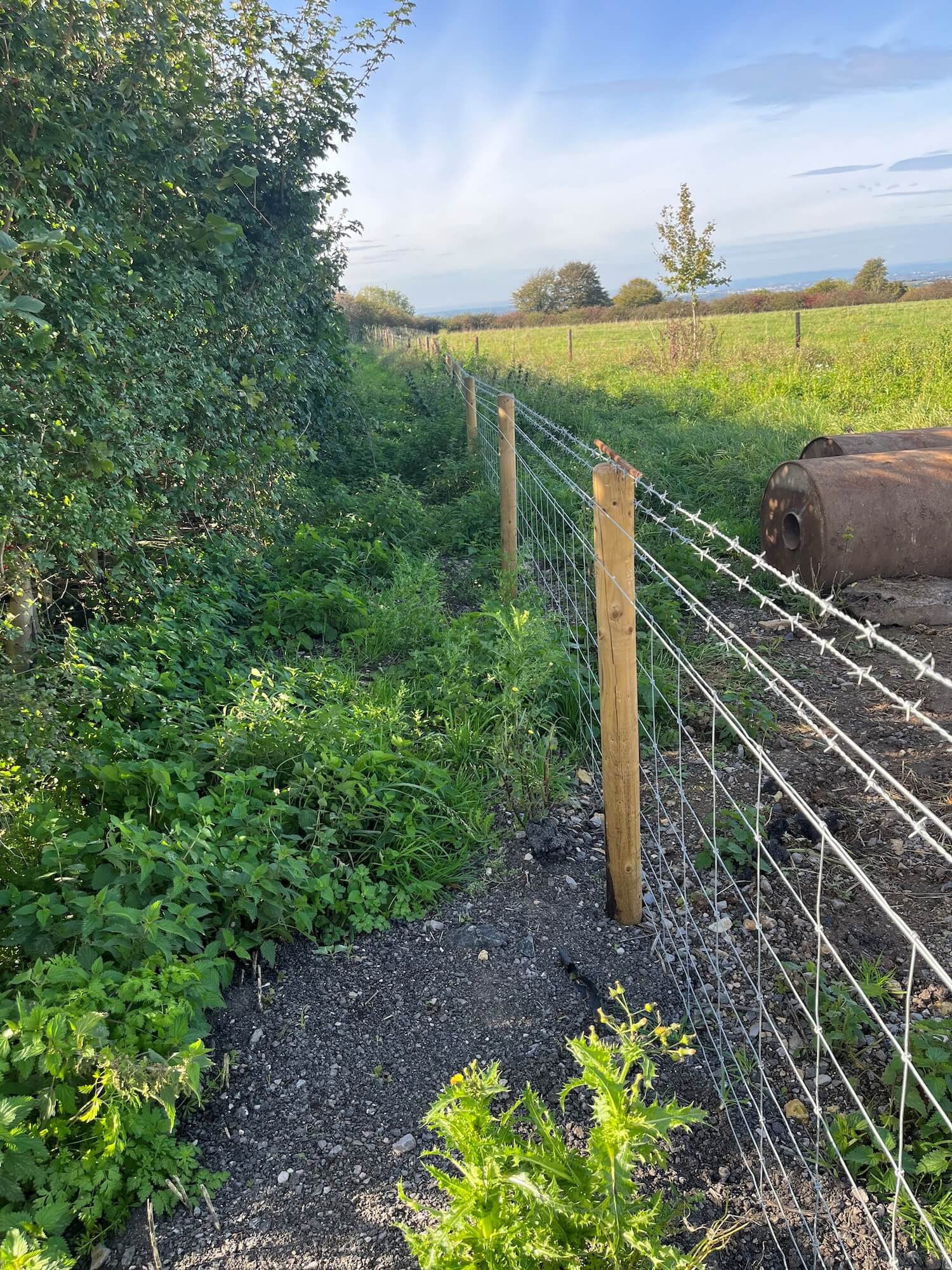
Cross the A420 at the point identified by the larger verge, and turn left.
Look for the path through the trees. Continue past Lilliput Farm Kitchen and locate the path behind the hedge running alongside the A420.
4. Continue towards Freezing Hill Lane
Cross Gorse Lane and then cross back over the A420 to reach Freezing Hill Lane.
Continue along the right-hand side of the road, taking care around traffic and checking that it is safe before crossing any road.
5. Take the farm footpath
Look for the footpath cut behind the hedge on the right-hand side of the road. The entrance is to the left of the large red sign.
Follow the footpath until you reach the farm entrance.
6. Enter Toghill House Farm
Go through the wooden gate displaying the “No Entry” sign. This sign applies to vehicles only; walkers should use this gate to enter the property.
Please follow the marked pedestrian route and respect any signs or access restrictions along the way.
Where to Get Food and Supplies While Walking
Food planning is an important part of preparing for a day’s walking, particularly on rural sections where shops and cafés may be limited. If you’re walking towards Bath, the final approach offers opportunities to pick up supplies before reaching the city.
It’s worth checking opening hours and planning your stops in advance rather than assuming that refreshments will be available whenever you need them.
Picking Up Lunch in Weston Village
For walkers continuing towards Bath, Weston Village is a useful place to consider stopping for lunch or picking up supplies. Depending on your pace and starting point, it may fit naturally into the latter part of your walk.
Options in the village include a bakery, a café, a Spar and a Tesco Express. These provide opportunities to buy something to eat, replenish snacks or pick up provisions for the remainder of the day.
If you’re walking a longer stage, consider taking a proper break rather than relying entirely on snacks. A little time to rest and refuel can make the final miles into Bath more enjoyable.
Remember to carry enough water for the section ahead, particularly in warmer weather. Shops and cafés may not be conveniently placed along every part of the route, and opening hours can vary.
Planning Your Evening Meal
If you’re staying at Toghill House Farm, it’s worth arranging your evening meal in advance. There aren’t suitable evening dining options within easy walking distance, so planning ahead will help you relax after a day on the trail.
There are several options to consider:
Option 1 – Pick up food earlier in the day
You could stop at Dyrham Park or The Fine Cheese Company at Tolldown Farm to enjoy lunch and pick up sandwiches or other food to eat later. Check opening times and availability before setting out, particularly if you’re planning to rely on a particular stop.
This option is useful if you’d prefer to settle in at the accommodation after walking rather than travel out again in the evening.
Option 2 – Eat out on Lansdown
The Hare & Hounds on Lansdown is another option to consider for an evening meal. If you plan to eat there, book a table in advance and arrange an Uber or other suitable transport for the journey there and back.
Check availability and transport arrangements before relying on this option, especially if you’re arriving later in the day.
Option 3 – Order a takeaway
You will probably be able to order a takeaway for delivery to the accommodation through the Just Eat, Uber Eats or Deliveroo apps, including everything from pizza and fish and chips to pub classics.
Best Time of Year to Walk the Cotswold Way Near Bath
The Cotswold Way can be walked throughout the year, and every season brings a different character to the countryside around Bath. The best time for your visit will depend on the weather you prefer, the length of your walk and how comfortable you are with changing trail conditions.
Spring
Spring brings fresh growth, greener fields and the return of colour to the countryside. Woodland paths and hedgerows become particularly attractive as the season progresses, while the weather can be pleasant for walking without the heat of summer.
Conditions can still be unpredictable, however, and paths may be muddy after rain. Waterproofs and footwear with good grip are advisable.
Summer
Longer daylight hours make summer a popular time for walking the Cotswold Way. The open countryside around Lansdown is particularly appealing in fine weather, and clear conditions can provide excellent views towards Bath and the surrounding hills.
Warm days can make exposed sections feel tiring, so carry sufficient water, use sun protection and avoid setting out too late if you’re planning a longer stage. The route can also be busier during school holidays and weekends.
Autumn
Autumn brings changing colours to the trees and hedgerows, along with softer light and often excellent walking conditions. The elevated viewpoints can be particularly rewarding on clear days.
As the season progresses, rain and falling leaves can make paths slippery. Daylight hours also become shorter, so check the forecast and plan your finishing time carefully.
Winter
Winter walking can be peaceful, with quieter paths and far-reaching views when the weather is clear. However, cold temperatures, wind, rain and muddy ground can make the route more demanding.
Choose your distance conservatively, wear suitable layers and waterproof clothing, and carry a torch if there is any possibility of finishing close to dusk. In poor weather, a shorter walk may be a better choice than attempting a full stage.
Whatever time of year you visit, check the weather forecast and current trail conditions before setting out. Allow extra time if the ground is wet or visibility is poor.
Getting to the Cotswold Way From Bath
Bath is well connected by public transport, making it a convenient destination for walkers who want to explore the Cotswold Way without relying entirely on a car.
- By train: Bath Spa railway station is the main railway station serving the city. From there, you can reach Bath Abbey and the city centre on foot.
- By bus: Local bus services may provide useful connections between Bath and parts of the surrounding area. Routes and timetables can change, so check current services before planning a walk around a bus journey.
- By taxi: A taxi can be a practical option for reaching a trailhead or returning from a walk, especially in rural areas where public transport is limited.
- By car: Driving gives you flexibility when choosing a starting point, but parking availability varies. Check the arrangements at your chosen location and avoid leaving your vehicle somewhere that restricts access or is not intended for public parking.
For point-to-point walks:
If you’re walking from Cold Ashton into Bath, or choosing another linear section, consider the journey at both ends before setting out. A little planning can save you a long wait or an unexpected extra walk at the end of the day.
If you’re staying at Toghill House Farm, also allow for the approximately 1.5-mile walk between the accommodation and the main Cotswold Way route. Use the recommended pedestrian directions rather than choosing a shorter-looking route along busy roads.
What to Take With You
The amount you need to carry with you depends on the distance you’re walking and the conditions, but a few essentials will help make your day more comfortable and keep you safe:
- Walking boots or suitable footwear: Choose footwear with good grip and support for uneven, muddy or slippery paths.
- Waterproofs: Weather can change quickly, particularly on exposed sections of the route.
- Water: Carry enough for your planned distance, taking account of the weather and opportunities to refill.
- Snacks: Energy bars, fruit or other easy-to-carry food can be useful between stops.
- A map or offline navigation: Download your route or carry a suitable map so that you can navigate even where mobile coverage is limited.
- Sun protection: A hat, sunglasses and sun cream are worthwhile in warmer weather.
- A portable charger: Navigation apps can use a considerable amount of battery, so keep your phone charged.
- Food for the evening: If you’re staying somewhere without convenient evening dining options, arrange provisions in advance.
- A small first-aid kit: Useful for minor blisters, grazes or other everyday problems.
- A torch: Particularly helpful in winter or if your walk takes longer than expected.
If you’re walking a full stage, make sure your pack contains everything you’ll need for the day. If you’re choosing a shorter route, you can travel lighter, but don’t leave out essentials simply because the walk looks straightforward.
Where to Stay When Walking the Cotswold Way Near Bath
Choosing the right accommodation can make a real difference to a walking break. A comfortable place to stay gives you somewhere to rest between stages, organise your kit and prepare for the following day’s walk.
Toghill House Farm is situated in the countryside near Bath, approximately 1.5 miles from the main Cotswold Way route. Its location makes it worth considering if you’re planning to explore the final section of the trail, enjoy shorter walks in the surrounding countryside or combine walking with a visit to the Heritage City of Bath.
The additional distance between the property and the National Trail is an important practical consideration. You should include it in your total mileage and allow enough time to follow the recommended pedestrian route between the Farm and Cotswold Way in both directions. Some of the nearby roads are busy and unsuitable for walking, so don’t simply follow a satnav’s shortest road route on foot.
For walkers completing the final stage into Bath, staying outside the city can provide an alternative to a city-centre overnight stop. You can enjoy the countryside setting while remaining within reach of Bath’s historic attractions, shops and transport connections.
With a little preparation, Toghill House Farm can provide a useful base for enjoying the countryside around Bath while making the most of your time on the Cotswold Way.
Planning Your Cotswold Way Walk Near Bath
A successful walking day starts with a realistic plan. Whether you’re tackling the final stage of the National Trail or stepping out for a few hours around Lansdown, it’s worth taking a little time to prepare.
- Choose your route and distance. Decide whether you want a full day from Cold Ashton to Bath, a shorter section around Lansdown or a circular walk towards Kelston Roundhill. Check the distance, estimated walking time and elevation before setting out.
- Allow for the additional distance to your accommodation. If you’re staying at Toghill House Farm, remember that the property is approximately 1.5 miles from the main trail. Include this extra walking in your daily mileage.
- Check the weather and trail conditions. Rain, mud, wind and reduced daylight can all affect how quickly you progress. Adjust your plans if conditions are poor.
- Plan lunch and your evening meal. Identify suitable places to stop for food and carry enough water and snacks. If you’re staying at Toghill House Farm, arrange your evening food before arriving.
- Save your directions and maps offline. Mobile coverage can vary, and having a route available offline is a useful precaution. Make sure you know how to identify the correct footpaths.
- Follow the recommended pedestrian route. Do not walk along Gorse Lane. Use the directions via Cold Ashton and the surrounding countryside, taking care at the A46 and A420 crossings.
- Arrange transport where necessary. For point-to-point walks, check your return journey before leaving. If you’re using a bus or taxi, confirm current availability and timings.
- Leave enough time to enjoy the walk. The Cotswold Way is as much about the experience as reaching the destination. Pause to appreciate the views, take photographs and enjoy the changing landscape as the countryside gives way to Bath.
With its combination of open hills, historic landmarks, countryside paths and a memorable finish at Bath Abbey, the Cotswold Way near Bath offers a rewarding walking experience.